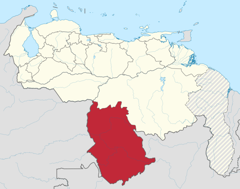
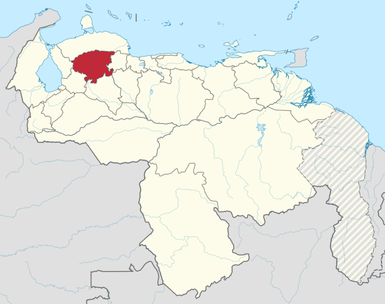
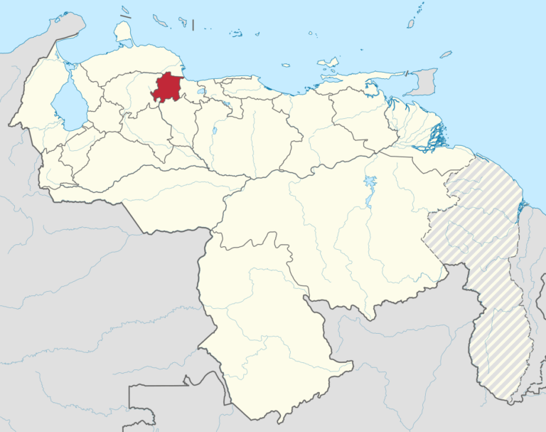
Amazonas
Amazonas (officially known as the Indigenous State of Amazonas) is one of the twenty-three states that, together with the Capital District and the Federal Dependencies, make up the Bolivarian Republic of Venezuela. Its capital, Puerto Ayacucho, concentrates 63% of the total population. It is located in the south of the country, in the Guayana region, bordered to the north by the State of Bolivar, to the northwest by the State of Apure in a small line at the confluence of the Meta River, to the east and south by Brazil through the watershed of the Orinoco and Amazon basins, and to the west by Colombia, mainly using the Atabapo, Orinoco and Negro rivers as borders. With an estimated 176,614 inhabitants, it is the least populated state, with an area of 177,617 km², the second largest state, and with 1 inhab/km², the one with the lowest population density. It is composed of 7 municipalities and 23 parishes. Its main localities apart from the capital are: La Esmeralda, San Fernando de Atabapo and San Carlos de Rio Negro.
Anzoátegui
Anzoátegui is one of the twenty-three states that, together with the Capital District and the Federal Dependencies, make up Venezuela. Its capital and most populated city is Barcelona. It is located in the northeastern region of the country, bordered to the north by the Caribbean Sea (Atlantic Ocean), to the northeast by Sucre, to the east by Monagas, to the south by the Orinoco River, which separates it from Bolívar, to the west by Guárico and to the northwest by Miranda. With 43 300 km² it is the sixth largest state (behind Bolívar, Amazonas, Apure, Guárico and Zulia) and 1 890 847 inhabitants, being (according to Venezuela’s INE) the seventh most populated in the nation, behind the states of Zulia, Miranda, Carabobo, Distrito Capital, Lara and Aragua.
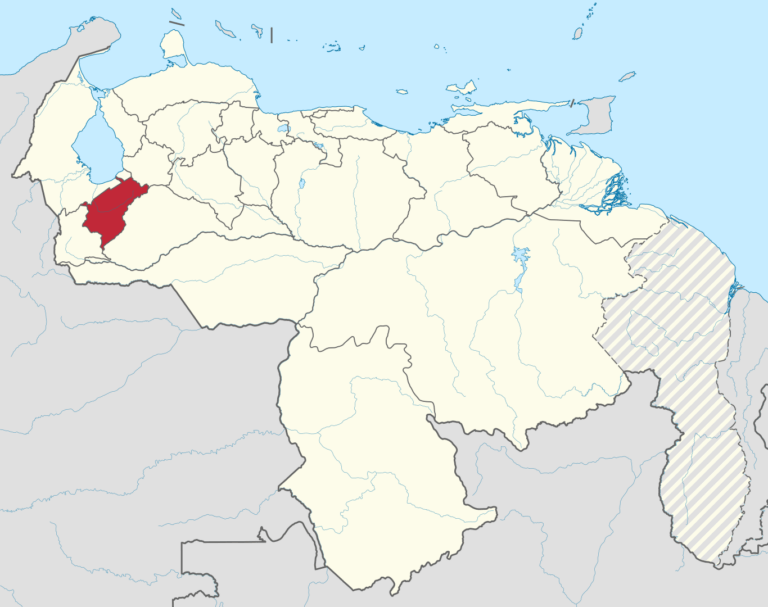
Apure
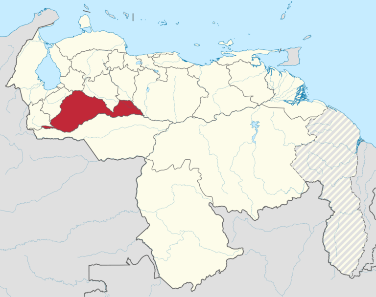
Apure is one of the twenty-three states that, together with the Capital District and the Federal Dependencies, form the Bolivarian Republic of Venezuela. Its capital is San Fernando de Apure. It is located in the southwest of the country, in the region of Los Llanos, bordering Táchira, Barinas and Guárico to the north, Bolívar to the east, Amazonas to the southeast and Colombia to the south. With 76,500 km² it is the third largest state -behind Bolívar and Amazonas-, with 679,169 inhabitants in 2024, according to estimates and projections of the Venezuelan INE. It is the fifth least populated, ahead of La Guaira, Cojedes, Delta Amacuro and Amazonas. And with 7.88 inhabitants/km², it is the third least densely populated, ahead of Delta Amacuro and Amazonas. Its relief is almost completely flat, with extensive plains that go from the confluence of the rivers Apure, Arauca and Capanaparo with the Orinoco, to the foothills of the Andes. With few terrain features, altitude oscillations fluctuate between 40 and 200 meters above sea level.
Aragua
Aragua is one of the twenty-three states that, together with the Capital District and the Federal Dependencies, form the Bolivarian Republic of Venezuela. Its capital is Maracay. It is located in the center-north of the country, in the Central region. It is bordered to the north by the Caribbean Sea, to the east by the state of Miranda, to the south by Guárico and to the west by Carabobo. According to INE projections for the year 2023, it has 2,068,820 inhabitants, making it the seventh most populated state.
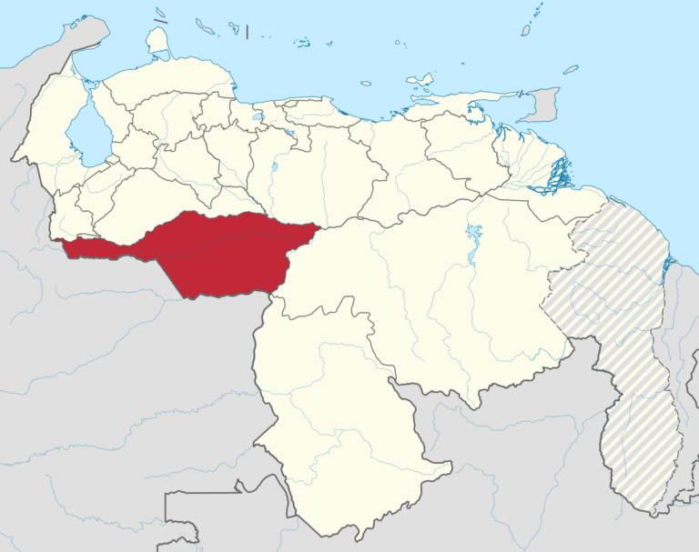
Barinas
Barinas is one of the twenty-three states that, together with the Capital District and the Federal Dependencies, make up the Bolivarian Republic of Venezuela. Its capital is the homonymous city of Barinas. It is part of the southwestern part of the country and occupies a large part of the western plains on the left bank of the Apure River, as well as a large part of the Andean Piedemonte mountain range, in the eastern part of the Mérida mountain range. Politically and administratively, it is part of the Andes and Los Llanos region, bordered to the north by the states of Cojedes, Portuguesa and Trujillo; to the east by the state of Guárico; to the south by the state of Apure and to the west by the states of Mérida and Táchira. With 35,200 km² it is the eighth largest state in terms of extension, and with an estimated 916,125 inhabitants – and therefore a population density of 37.3 inhabitants/km² – it is the eleventh in terms of population and the seventeenth in terms of population density. It is an important economic center of the Venezuelan plains, with an important livestock and oil industry.
Bolívar
Bolívar is one of the 23 states of Venezuela. The state capital city is Ciudad Bolívar and the largest city is Ciudad Guayana. Bolívar State covers a total surface area of 242,801 km2 (93,746 sq mi) and as of the 2011 census, had a population of 1,410,964. The state contains Angel Falls.

Carabobo
Carabobo is one of the twenty-three states that, together with the Capital District and the Federal Dependencies, make up the Bolivarian Republic of Venezuela. Its capital is Valencia. It is located in the center-north of the country, in the Central region. It is bordered to the north by the Triste Gulf, to the east by Aragua, to the south by Guárico and Cojedes, and to the west by Yaracuy. With 4650 km², it is the third least extensive state – ahead of Estado La Guaira and Nueva Esparta, the least extensive. With 2 813 161 inhabitants in 2016, it is the third most populated – behind Zulia and Miranda – and with 713 inhab./km² (inhabitants per square kilometer), the most densely populated.
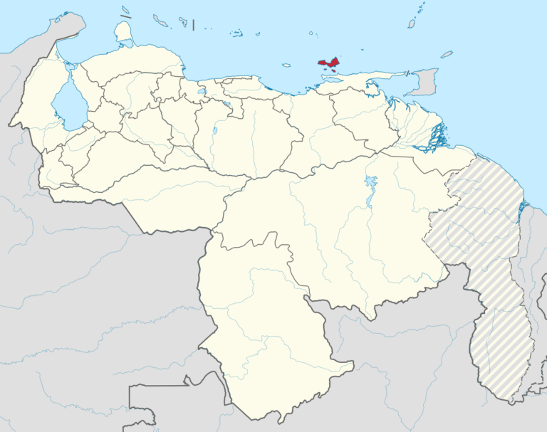
Cojedes
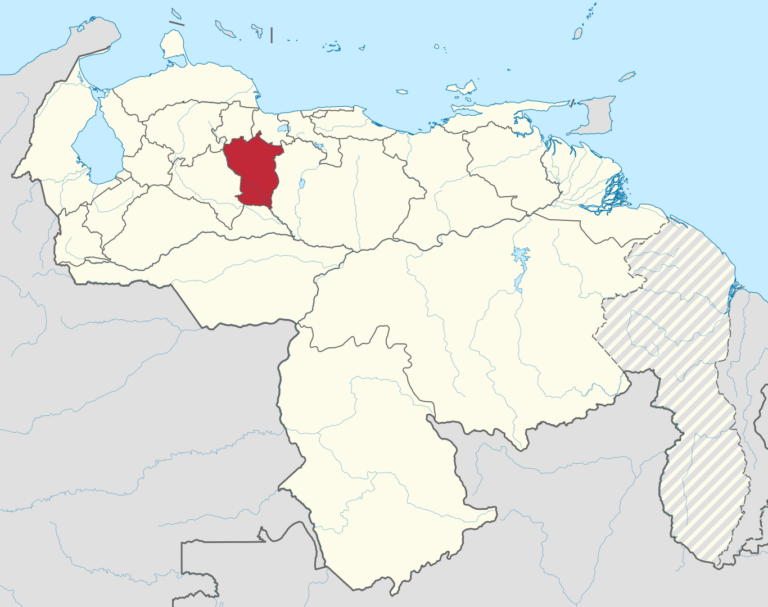
Cojedes is one of the twenty-three states that, together with the Capital District and the Federal Dependencies, form the Bolivarian Republic of Venezuela. Its capital is San Carlos. It is located in the center-northwest of the country, in the Central region of the country. It is bordered to the north by Yaracuy and Carabobo, to the east by Guárico, to the south by Barinas, to the west by Portuguesa and to the northwest by Lara. With 401,530 inhabitants, in 2023 it was the third least populated state, ahead of Delta Amacuro and Amazonas. It has 9 autonomous municipalities and 15 civil parishes. Its main cities are: San Carlos, Tinaquillo, Tinaco, Las Vegas (Romulo Gallegos), El Pao and Macapo.
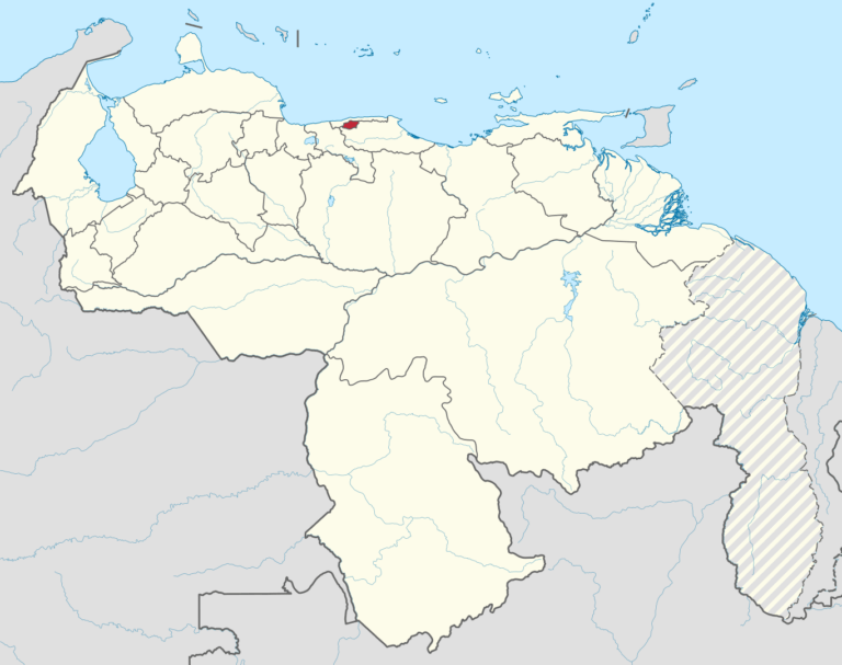
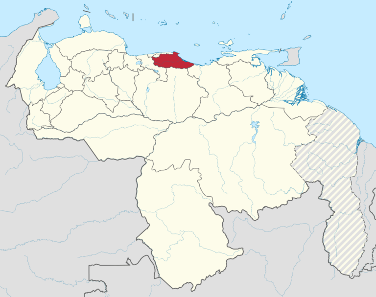
Delta Amacuro
Delta Amacuro is one of the twenty-three states that, together with the Capital District and the Federal Dependencies, make up the territory of Venezuela.
It is located in the Guayana region. With 40,200 km², it is the seventh largest – behind Bolívar, Amazonas, Apure, Guárico, Zulia and Anzoátegui – and with 4.65 inhabitants/km², the second least densely populated, behind Amazonas.1
It has 4 autonomous municipalities and 20 civil parishes. Its main cities are: Tucupita, Sierra Imataca, Pedernales and Curiapo.
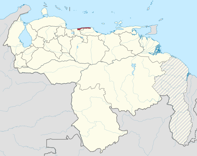
Distrito capital
The Capital District (formerly called Federal District) is a federal entity, which together with the twenty-three states and the Federal Dependencies, form Venezuela. It is located in the area of the Coastal Mountain Range (north-central part of the country), in the Capital Region. It is part of the city of Caracas, which is also the capital of the republic. The National Public Powers have their seat in the Capital District. This entity has federal rank and the competence to organize this territory; it has a particular political organization. It has an area of 433 km² and contains the western part of the Metropolitan District of Caracas.
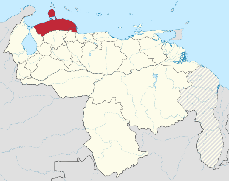
Falcón
Falcón is one of the twenty-three states that, together with the Capital District and the federal dependencies, form the Bolivarian Republic of Venezuela. It was named in honor of Juan Crisóstomo Falcón, leader of the Federal War. Its capital is Coro, founded on July 26, 1527.
It is located in the Central Western Region. It is bordered to the north by the Gulf of Venezuela, the Caribbean Sea (Atlantic Ocean) and the leeward group of the Netherlands Antilles (Aruba, Curacao and Bonaire); to the east by the Triste Gulf (Caribbean Sea); to the south by the states of Yaracuy and Lara, and to the west by the state of Zulia.
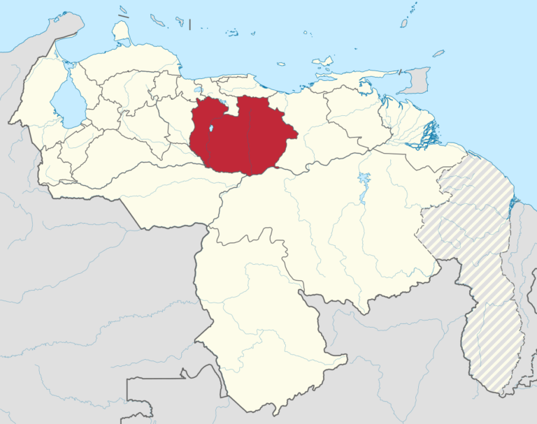
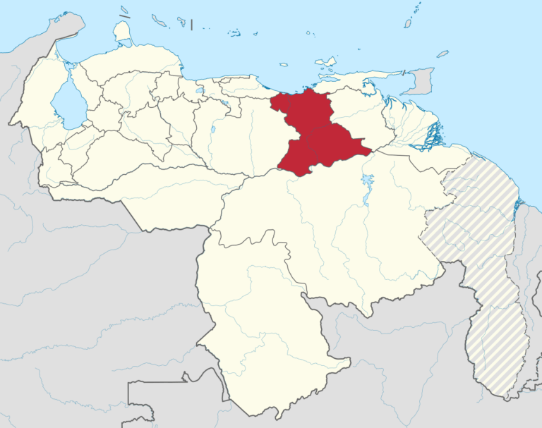
Guárico
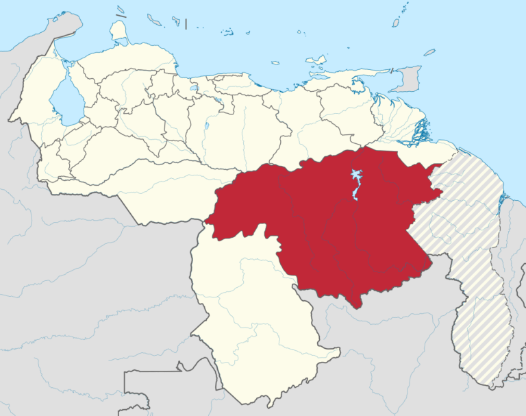
Guárico is one of the twenty-three states that, together with the Capital District and the Federal Dependencies, make up the Bolivarian Republic of Venezuela. Its capital is San Juan de los Morros and its most populated city is Calabozo. It is located in the center of the country, in the Los Llanos region, bordered to the north by Carabobo, Aragua and Miranda, to the east by Anzoátegui State, to the south by Bolívar and Apure, and to the west by Barinas and Cojedes. With almost 65,000 km² it is the fourth largest state, behind Bolivar, Amazonas and Apure, while with 855,381 inhabitants in 2023 – ahead of Trujillo, Yaracuy, Nueva Esparta, Apure, Vargas, Cojedes, Delta Amacuro and Amazonas – and 11.5 inhabitants/km², it is the fifth least densely populated, ahead of Bolivar, Apure, Delta Amacuro and Amazonas.
It has 15 autonomous municipalities and 39 civil parishes. Its main cities are Calabozo, San Juan de los Morros, Valle de la Pascua, Zaraza and Altagracia de Orituco.
La Guaira
La Guaira State (Spanish: Estado La Guaira), known until 2019 as Vargas State (Spanish: Estado Vargas, IPA: [esˈtaðo ˈβaɾɣas]), is one of the 23 states of Venezuela.
Formerly named after Venezuela’s first civilian president, José María Vargas, the state comprises a coastal region in the north of Venezuela, bordering Aragua to the west, Miranda to the east, the Caribbean Sea to the north and the Capital District to the south. It is home to both the country’s largest seaport and airport. The state capital and largest city is La Guaira followed by Catia La Mar and Maiquetía. The Litoral Varguense conurbation is the principal urban agglomeration in the state, which is part of the Greater Caracas Area.
In 1999, the geographic center of the state suffered major floods and landslides, known as La Tragedia de Vargas (the Vargas tragedy), causing major losses of life and property, and resulting in forced population movements, including the virtual disappearance of some small towns. Thousands died, and many more fled the area to other states. The state’s name was changed on 14 June 2019 to La Guaira.
Lara
Lara is one of the twenty-three states that, together with the Capital District and the Federal Dependencies, make up Venezuela. Its capital is Barquisimeto. It is located in the Central Western Region of the Bolivarian Republic of Venezuela, bordered to the north by Falcón, to the east by Yaracuy, to the south by Portuguesa, to the southeast by Cojedes, to the southwest by Trujillo and to the west by Zulia. With 2,142,583 inhabitants in 2023, it is the fourth most populated state, after Zulia, Miranda and Carabobo. It has 9 autonomous municipalities and 57 civil parishes. Its main cities are: Barquisimeto, Carora, El Tocuyo, Quíbor and Cabudare.
Mérida
Mérida is one of the twenty-three states that, together with the Capital District and the Federal Dependencies, make up the Bolivarian Republic of Venezuela. It is located in the Andes region and its capital is the homonymous city of Mérida; it is bordered to the north by Zulia and Trujillo, to the east by Barinas and to the south and west by Táchira, its population is estimated at 1,031,017 inhabitants for the year 2023 according to the I.N.E., and it is characterized by an important agricultural and tourist activity.
It is located on the Andes Mountain Range and in its territory is located one of the highest peaks of the Andes, the Pico Bolivar, reaching 4978 meters above sea level. It is administratively subdivided into 23 municipalities and 86 civil parishes. Its main cities are: Mérida, El Vigía, Tovar, Ejido, Lagunillas and Nueva Bolivia.
Miranda
Miranda is one of the twenty-three states that make up Venezuela, together with the Capital District and the Federal Dependencies, whose capital is Los Teques. It is located in the center-north of the country, in the Capital region. It is bordered to the north by the state of La Guaira, the Capital District and the Venezuelan Caribbean Sea, to the east by the Caribbean Sea, to the southeast by the state of Anzoátegui, to the south by the state of Guárico and to the west by the state of Aragua. With 4,088,343 inhabitants in 2023, it is the second most populated state with 7950 km², the ninth least extensive and with 336.5 inhabitants/km², the fourth most densely populated.
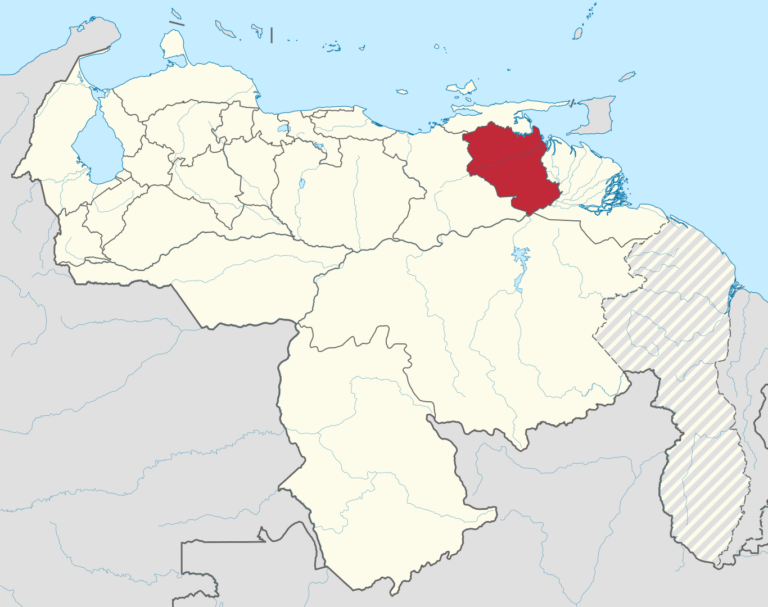
Monagas
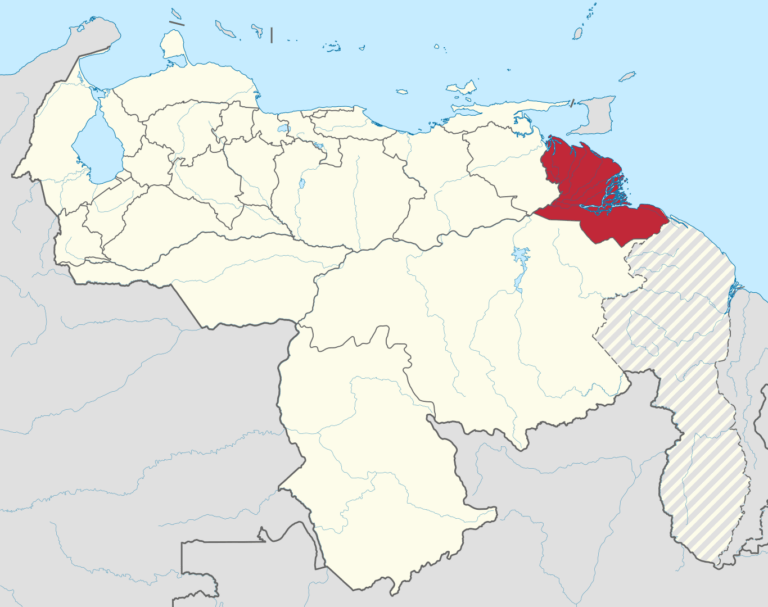
Monagas is one of the twenty-three states that, together with the Capital District and the Federal Dependencies, form the Bolivarian Republic of Venezuela. Its capital is Maturín and it is also its most populated city.
It is located in the northeastern region of the country, bordering Sucre to the north, the Gulf of Paria (Atlantic Ocean) to the northeast, Delta Amacuro state to the east, Bolívar state to the south and Anzoátegui state to the west. With 28 900 km² it is the ninth largest state and with 1 090 159 inhabitants in 2023, the 12th most populated.
It has 13 autonomous municipalities and 43 civil parishes. Its main cities are Maturín, Punta de Mata, Caripe, Caripito and Temblador. The state owes its name to José Tadeo, José Gregorio and José Ruperto Monagas, the three presidents of Venezuela during the 19th century.
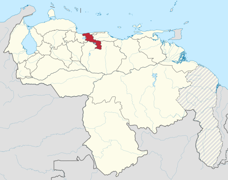
Nueva Esparta
Nueva Esparta is one of the twenty-three federal states, which, together with the Capital District and the Federal Dependencies, form the Bolivarian Republic of Venezuela. Its capital is La Asunción and its most populated city is Porlamar. It is an archipelago formed by three islands in the Caribbean Sea: Margarita Island, Coche Island and Cubagua Island in the insular region of Venezuela, being the only island state of the country, which is also part of the Lesser Antilles of the Caribbean Sea.
It is located in the northeastern insular region of the country, and borders the Caribbean Sea in its four cardinal points. With 1150 km², it is the smallest state in the country, with 596,842 inhabitants. In 2023, it was the sixth least populated – ahead of Apure, Vargas, Cojedes, Delta Amacuro and Amazonas, the least populated – and, with 480 inhabitants/km², the second most densely populated, behind Carabobo.
It is located north of the Araya Peninsula and is divided into 11 autonomous municipalities and 23 civil parishes. Its main cities are: La Asunción, Porlamar, Juan Griego, Punta de Piedras, Pampatar, San Juan Bautista and El Valle del Espíritu Santo.
Portugesa
Portuguesa is one of the twenty-three states that, together with the Capital District and the Federal Dependencies, form the Bolivarian Republic of Venezuela. Its capital is Guanare. It is located in the central-western region bordering Lara to the north, Cojedes to the east, Barinas to the south and Trujillo to the west. It has 14 autonomous municipalities and 39 civil parishes. Its main cities are: Guanare, Acarigua and Araure. It is considered “El Granero de Venezuela” (Venezuela’s granary) due to the large amount of agricultural products obtained there.
Sucre
Sucre is one of the twenty-three states that, together with the Capital District and the Federal Dependencies, make up Venezuela. Its capital is Cumaná. It is located in the northeastern region of the country, bordered to the north by the Caribbean Sea, to the east by the Gulf of Paria, to the south by Monagas, to the southwest by Anzoátegui and to the west by the Gulf of Cariaco. It is composed of 15 municipalities divided into 57 parishes. It owes its name to the Gran Mariscal de Ayacucho Antonio José de Sucre.
Táchira
Táchira is one of the twenty-three states that, together with the Capital District and the Federal Dependencies, make up the Bolivarian Republic of Venezuela. Its capital is the city of San Cristóbal and it is located in the western part of the country, in the Andes region. It is bordered to the north by Zulia, to the northeast by Merida, to the south by Barinas and Apure, and to the west by the Republic of Colombia. With an area of 11 100 km², it is the eighth least extensive state and, with 1 416 625 inhabitants in 2023, it is the ninth most populated.1
It is made up of 29 autonomous municipalities and 66 civil parishes. Among its main cities are San Cristóbal, Táriba, Rubio, La Grita, San Antonio del Táchira, La Fría, Santa Ana del Táchira, Capacho Nuevo, San Juan de Colón, Cordero2 and Capacho Viejo. Its average temperature is between 10 and 25 °C.
Trujillo
Trujillo is one of the twenty-three states that, together with the Capital District and the Federal Dependencies, make up the Bolivarian Republic of Venezuela. Its capital is the homonymous Trujillo and its most populated city is Valera. It is located in the west of the country, in the Andes region. It is bordered to the north by Zulia and Lara, to the east by Portuguesa, to the south by Barinas, to the southwest by Mérida and to the west by Lake Maracaibo. With 7400 km² it is the sixth least extensive state – ahead of Yaracuy, Aragua, Carabobo, Vargas and Nueva Esparta, the least extensive – and with 887,064 inhabitants in 2023, the eighth least populated, ahead of Yaracuy, Nueva Esparta, Apure, Vargas, Cojedes, Delta Amacuro and Amazonas, the least populated.
It has 20 autonomous municipalities and 93 civil parishes. Its main cities are: Trujillo, Valera, Boconó and Carvajal.
Yaracuy
Yaracuy est l’un des vingt-trois États qui, avec le district de la capitale et les dépendances fédérales, forment le Venezuela. Sa capitale est San Felipe. Il est situé dans la région centre-ouest de la République bolivarienne du Venezuela, bordé au nord par Falcón, au nord-est par le Golfo Triste (mer des Caraïbes, océan Atlantique), à l’est par Carabobo, au sud par Cojedes et à l’ouest par Lara. Avec 7100 km², c’est le cinquième État le moins étendu – devant Aragua, Carabobo, La Guaira et Nueva Esparta, le moins étendu – et il comptera 859 474 habitants en 2023.
Il compte 14 municipalités autonomes et 21 paroisses civiles. Ses principales villes et municipalités sont San Felipe, Yaritagua, Independencia, Chivacoa, Cocorote, Nirgua et Urachiche. Yaracuy possède également des attractions touristiques telles que le parc récréatif du barrage Cumaripa, le parc de la flore tropicale exotique à San Felipe, l’auberge et le camp Navajivan à Nirgua, le parc national Yurubí et la montagne Sorte, classée patrimoine culturel, qui jouit d’une renommée nationale et internationale en raison des pratiques de sorcellerie, d’occultisme et de vaudou qui y sont pratiquées.
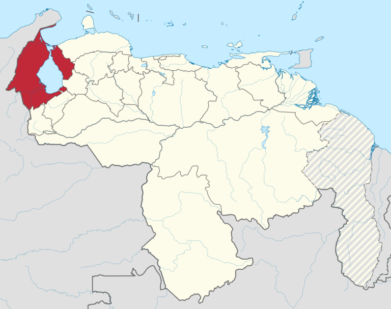
Zulia
Zulia State is one of the 23 states of Venezuela. The state capital is Maracaibo. As of the 2011 census, it has a population of 3,704,404, the largest population among Venezuela’s states. It is also one of the few states (if not the only one) in Venezuela in which voseo (the use of vos as a second person singular pronoun) is widespread. The state is coterminous with the eponymous region of Zulia.
Zulia State is in northwestern Venezuela, bordering Lake Maracaibo, the largest body of water of its kind in Latin America. Its basin covers one of the largest oil and gas reserves in the Western Hemisphere.
Zulia is economically important to the country for its oil and mineral exploitation, but it is also one of the major agricultural areas of Venezuela, highlighting the region’s contribution in areas such as livestock, bananas, fruits, meat, and milk.